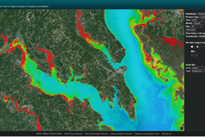
NASA's new Satellite-based Analysis Tool for Rapid Evaluation of Aquatic Environments (STREAM) is a powerful data processing tool designed to rapidly ingest, process, and display water quality maps. Developed by NASA’s Goddard Space Flight Center and Science Systems and Applications, Inc. (SSAI), STREAM leverages data from Landsat 8 and 9 Operational Land Imager (OLI) and Copernicus Sentinel-2 Multispectral Instrument (MSI), providing high-resolution water quality products globally validated and processed using machine learning.
STREAM allows users to visualize water quality maps, identify pixel values, and view time-series plots for specific regions, enabling low-latency detection (under six hours) of water quality anomalies. It offers insights into chlorophyll-a concentrations, Secchi disk depth (water transparency), and total suspended solids (TSS). The satellite images, sourced from the USGS Landsat Project and the Copernicus Open Access Hub, are processed through two independent machine-learning streams. STREAM also integrates tools from NASA’s near real-time data systems, notably the Fire Information for Resource Management System (FIRMS).
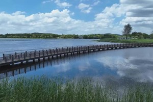
The tool was developed to enhance decision-making in coastal and lake resource management, particularly benefiting fisheries, aquaculture, and recreation. STREAM emerged from a 2017 workshop at NASA Goddard, which brought together a diverse group of experts to explore satellite-based water quality monitoring. It has since been beta-tested in Peru, Uruguay, and the continental United States.
STREAM 1.0 offers water quality maps for selected U.S. regions and parts of Peru, Uruguay, Uganda, Tanzania, Kenya, Ghana, Benin, and Senegal, with historical data from 2014-2023 and near real-time processing for 2024 onwards. STREAM 2.0 aims to expand coverage globally, extend image processing back to 2013, and introduce additional services, including a user forum. Future enhancements will incorporate data from NASA’s PACE and SBG missions, the upcoming Landsat Next mission, and the Copernicus Sentinel-3 mission.
The SSAI Freshwater Sensing Program, which supports STREAM, focuses on providing reliable global water products from satellite observations to promote sustainable aquatic ecosystems. This initiative is funded by various NASA programs and supported by the USGS Landsat Science Team.
By Josh Blumenfeld