

The Hull Conservation Commission unanimously approved Woods Hole Oceanographic Institution’s (WHOI) Request for Determination of Applicability (RDA) to deploy water sensors along Hull’s coastline for monitoring sea level rise.
WHOI selected Hull due to its vulnerability, offering insights into local flooding. Sarah Das, WHOI scientist and RDA author, emphasized the sensors' role in understanding sea level rise's local impact. Each prototype costs approximately $300, reflecting WHOI's cost-effective approach.
Initial deployments at Woods Hole dock and Chatham Fish Pier have preceded collaborations with Hull’s climate adaptation director, Chris Krahforst, to identify sensor locations.
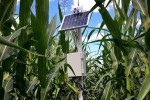
The sensors, resembling tissue boxes, incorporate a solar panel for power atop and an acoustic transducer below for measuring water levels using sonar-like technology. These devices aim to supplement NOAA's tide gauge network, which covers only a fraction of Massachusetts' coastline.
Das highlighted the need for more localized data to bridge gaps between community flood reports and NOAA's broader observations. Currently, only six NOAA tide gauges serve Massachusetts, spaced far apart.
WHOI’s sensors operate by emitting sound pulses to measure water level changes. Data collection occurs every 10 minutes, aggregating measurements into single averages transmitted via cellular data modems to the cloud.
Comparative studies with NOAA's Chatham tide gauge will validate the sensor's efficacy across diverse weather conditions. Recent data suggests a rapid sea level rise of two to three inches since 2022 in Massachusetts, prompting heightened data collection efforts.
The sensors promise to empower coastal communities with specific flood risk insights, crucial for local mitigation strategies. Das underscored their role in refining flood risk models and enhancing response measures.
Looking ahead, WHOI envisions extensive networks of coastal water sensors supporting evidence-based policymaking and scientific advancements in coastal flood management.
By Dolores Sauca Lorusso