The ability to remotely monitor river and stream levels is crucial for effective water management and reducing the impact of flooding and environmental hazards. Thanks to the Internet of Things (IoT) technology, continuous monitoring of river or creek levels in multiple locations has become more accessible and efficient.
With real-time data transmitted wirelessly, stakeholders can make informed decisions to safeguard communities, infrastructure, and the environment. This blog post delves into the components and sensors required to monitor river or creek levels, focusing on ultrasonic sensors.
The three most common sensors used to measure river levels with IoT are ultrasonic, radar and depth sensors. In this post, we are going to focus on the use of ultrasonic sensors.
To provide a simple explanation, we have broken the solution into Sensors, Network and Cloud.
- Sensors.
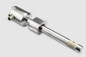
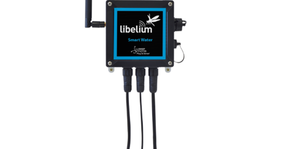
- Libelium Plug&Sense (Smart Water Xtreme or Smart Cities), with the Ultrasonic Sensor (Maxbotix MB7040). A radar sensor can be used in place of the ultrasonic sensor, with the added benefit of increased accuracy and range.
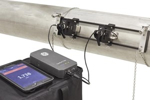
- Milesight EM500-UDL sensors incorporate a Maxbotix sensor, 19,000mAh battery and LoRaWAN. The IP67 sensor can be rapidly deployed and are suitable for harsh environments.
- Network. The Libelium Plug&Sense supports LoRaWAN and cellular 3G/4G. For remote locations, there is also the option of using a LoRaWAN-Satellite gateway.
- Cloud. A range of cloud platforms is supported. The most common platforms we work with include Microsoft Azure, AWS, custom web applications and conventional database systems.
Sensors
For this scenario, we will be using ultrasonic distance sensors. You may also want to include temperature, humidity and pressure, a weather station, and a water-flow meter for river applications.
An ultrasonic sensor emits sound toward an object and detects the sound reflecting to determine distance. The sensor then measures the time between each point to determine the distance between the sensor and the measured object. The sound emitted by the sensor is at a high frequency, inaudible to the human ear, but it allows for a focused ‘beam’ (42KHz).
A typical ultrasonic sensor can measure the distance from 30cm to 10m – with an accuracy of 1cm throughout this range. Sampling intervals can be as little as one minute, but ten minutes is more common.
How do I power the sensor?
The Libelium Plug&Sense includes a built-in 6000mA-H battery and support for an external solar panel. Using batteries and renewables allows the sensor nodes to be deployed in remote environments.
Milesight UDL-5000 is entirely battery-powered, with no requirement for solar panels or external power.
Network
Wireless technologies such as LoRaWAN and 3G/4G are supported by the Libelium Plug & Sense. The flexible range of options allows you to choose the right wireless technology to send data back to your systems or application servers. For very remote locations, a technology such as LoRaWAN (supported by the node) and a LoRaWAN-Satellite gateway allow water monitoring from anywhere in the world.
Cloud
Data from the sensors (once transmitted) needs to be processed and stored. The use of cloud platforms such as Microsoft Azure is perfect for IoT. However, the platform supports sending data to Azure, AWS and familiar application/database servers.
If you prefer an easy-to-use, customisable solution – we also support Datacake and Milesight Cloud.
Once in the cloud, you can develop additional functionality such as alerting and notifications (i.e. if the river level exceeds a given level or there is an upwards/downwards trend of significance).
Remote water level monitoring solution
The sensor node is strategically affixed to a river structure, such as a bridge, or mounted on a pole positioned near the river that requires monitoring. Connected to this node, the ultrasonic sensor is installed at a specific height above the body of water, where it continuously measures the distance between itself and the water surface.
Any fluctuations in the sensor’s readings can be accurately interpreted by establishing a reference point for the river’s depth at the monitoring location. For example, a decrease in the sensor value (e.g., 25 cm) would signify a drop in water levels, whereas an increase (e.g., +15 cm) would imply a rise in water levels.
Positioning
To ensure accurate data, selecting an appropriate mounting location for the sensor node that minimizes potential interference from debris or obstructions is essential. Additionally, regular maintenance and calibration of the ultrasonic sensor are crucial to guarantee the reliability of the measurements.
Considerations
When setting up a river level monitoring system, it’s essential to consider factors such as the river’s flow rate, seasonal variations, and the potential for sudden changes due to weather events. These considerations can help stakeholders set appropriate alert thresholds for proactive flood management and water resource planning.
Sampling Intervals
The sensor node will transmit this measurement back to the cloud platform. Measurement intervals can be as few seconds, but a practical range would be every 15 minutes. For higher-risk rivers or where pre-emptive flood detection is needed – you may want to measure levels every minute.
The only disadvantage of more aggressive sampling intervals is the battery life of the sensor node. More measurements mean more power consumption – an important consideration if the battery and solar panels power the sensor node.